This page contains data downloads for Piceance Basin, 2010 Oil Shale Assesment, compiled from DDS-69-Y.
Complete Spatial Data download (Zip File, 534MB) - All shapefiles, GRIDs, TINs, tabular data.
Borehole Locations ( Shapefile 46.7 kB, Metadata)
Nahcolite Boreholes ( Shapefile 14.5 kB, Metadata)
Mahogany Outcrop ( Shapefile 726 kB , Metadata)
Parachute Creek Member Outcrop ( Shapefile 165 kB , Metadata)
Mahogany Zone Overburden ( Shapefile .97 MB , Metadata)
Mahogany Zone Faults ( Shapefile 38.1 kB , Metadata)
Mahogany Ledge Structure Contour Lines ( Shapefile 1.43 MB , Metadata)
Barrels per Acre Oil Yield ( ESRI GRIDs 54.8 MB , Metadata)
Gallons per Ton Oil Yield ( ESRI GRIDs 53.1 MB , Metadata)
Isopach Thickness ( ESRI GRIDs 51.5 MB , Metadata)
Nahcolite ( ESRI GRIDs 53.1 MB , Metadata)
Mahogany Ledge Structure and Overburden ( ESRI GRIDs 1.09 MB , Structure Metadata, Overburden Metadata)
Mahogany Ledge Structure ( ESRI TIN 39.5 MB , Metadata)
Mahogany Zone Overburden ( ESRI TIN 1.36 MB , Metadata)
Tabular Data
Master Piceance Basin Oil Shale Database ( Microsoft Access database, Zipped with documentation 19.9 MB)
Master Piceance Basin Nahcolite Database ( Microsoft Access database, Zipped with documentation 11.1 MB)
This page contains data downloads for Uinta Basin, Utah 2010 Oil Shale Assesment, compiled from DDS-69-BB.
Complete Spatial Data download (Zip File, 495 MB) - All shapefiles, GRIDs, TINs, tabular data.
Borehole Locations ( Shapefile 35.5 kB, Metadata)
Mahogany Bed and Parachute Creek Outcrop ( Shapefile 2.06 MB , Metadata)
Mahogany Zone Overburden Shapefile 2.08 MB , Metadata)
Mahogany Ledge Structure Contour Lines ( Shapefile 810 kB , Metadata)
Barrels per Acre Oil Yield ( ESRI GRIDs 102 MB , Metadata)
Gallons per Ton Oil Yield ( ESRI GRIDs 102 MB, Metadata)
Isopach Thickness ( ESRI GRIDs 101 MB, Metadata)
Mahogany Ledge Structure and Overburden ( ESRI GRIDs 17.7 MB , Structure Metadata , Overburden Metadata)
Mahogany Ledge Structure (ESRI TIN 127 MB , Metadata)
Mahogany Zone Overburden (ESRI TIN 28.7 MB , Metadata)
Tabular Data
Master Uinta Basin Oil Shale Database ( Microsoft Access database, Zipped with documentation 19.9 MB)
This page contains data downloads for Eocene Green River Formation, 2011 Oil Shale Assesment, from DDS-69-DD.
Complete Spatial Data download (Zip File, 329 MB) - All shapefiles, GRIDs, TINs, tabular data.
Borehole Locations ( Shapefile 80.9 KB , Google KML 36 KB , Metadata)
Laney Member Outcrop ( Shapefile 44.7 KB , Metadata)
Tipton Member Outcrop ( Shapefile 53.2 KB , Metadata)
Barrels per Acre Oil Yield ( ESRI GRIDs 30.6 MB , Metadata )
Gallons per Ton Oil Yield ( ESRI GRIDs 29.8 MB , Metadata )
Isopach Thickness ( ESRI GRIDs 32.7 MB , Metadata )
LaClede bed Overburden and Structure ( ESRI GRID 18.8 MB , Overburden Metadata , Structure Metadata)
LaClede Bed Structure ( ESRI TIN 107 MB , Metadata)
LaClede Bed Overburden ( ESRI TIN 105 MB , Metadata)
Tabular Data
Master Green River Formation Oil Shale Database ( Microsoft Access database, Zipped with documentation 3.13 MB)
This page provides access to data that supports recent oil shale assessments and released as part of the 2009 update of OFR 98-483 .
MS Excel Spreadsheet (2.79 MB) | Comma-Delimited CSV (819KB) | Data Definitions (text)
Comma-Delimited CSV (4.5MB, zip compressed) | Data Definitions (text)
MS Access Database (6.85 MB, zip compressed) | Comma-Delimited CSV (4.67 MB, zip compressed)
Shapefile (44KB, zip compressed) | View in Google Earth (56KB KMZ) | Text Metadata (14 KB)
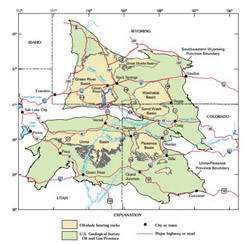
Oil shale data for the Piceance Creek Basin, Colorado is available as
USGS Data Series 181
and can be downloaded using the links below.
 This geodatabase is a digital reproduction of three legacy USGS oil shale publications--
MF-958 (Pitman and Johnson, 1978)
, MF-1069 (Pitman, 1979)
, and OC-132 (Pitman and others, 1990).
The database consists three feature datasets for each publication with a total of 106 feature classes.
This geodatabase is a digital reproduction of three legacy USGS oil shale publications--
MF-958 (Pitman and Johnson, 1978)
, MF-1069 (Pitman, 1979)
, and OC-132 (Pitman and others, 1990).
The database consists three feature datasets for each publication with a total of 106 feature classes.
Master Geospatial Database ( ESRI Geodatabase, Zipped 10 MB , 10MB, Text Metadata , XML Metadata)
2,263 scanned logs of various types including gamma ray, sonic, neutron, caliper, and lithologic descriptions are available for 621 different wells in the Piceance Basin of western Colorado. Logged intervals generally focus on the Green River Formation which contains large amounts of oil shale in this area. Image quality varies considerably with the condition of the starting material. Files are PDFs or TIFFs and file size ranges up to 560 megabytes with and an average size of 33 megabytes.
We are working on an interactive application to browse and query this catalog, but in the meantime you can use the following spreadsheet to access the logs individually:
Piceance Well Log Index Spreadsheet (XLS, 587 KB)